An International Journal
Agricultural and Biological Research
ISSN - 0970-1907
RNI # 24/103/2012-R1
RNI # 24/103/2012-R1
Research Article - (2023) Volume 39, Issue 4
Analyzing Land Use and Land Cover (LULC) helps to protect our agricultural landscapes in the urban areas under the background of rapid urbanization. This study examines the rate of urban expansion and variations of LULC from a period of 2000 to 2020 years using GIS for Patancheruvu block in Telangana, India. LULC analysis was done by using Land change Index and Integral Index of Connectivity (IIC) is used to estimate the ecological quality of the Patancheruvu. LULC analysis described that over the past 20 years period urban expanse happen more than doubled, resulting in a 34% increased. IIC analysis clarified that spatial connectivity of natural and agricultural land dropped from 0.72 to 0.25 from 2000 to 2020 respectively. It is concluded that obvious damage happened around local ecosystem. Therefore, the study results help to plan urban expansion by balancing economic development and ecological protection.
Ecosystem; Integral index of connectivity (IIC); Land use and land cover; Urbanization; Radioactive
Peoples are seen to be migrating to city areas from rural regions in search of better employment opportunities leading to an expansion of the cityscape with development of better infrastructure and housing. These advancements in urbanization are in a way aiding life in the cities, but in reality, have proved to be a boon as well as bane. Urbanization has resulted in changing the natural landscape of the region since dense forested areas to clear in order to accommodate roads, buildings and other concrete features that do not allow rain water to percolate [1]. With the advent of industrialization, the natural balance is disturbed, leading to major changes in the physical and surface characteristics of the region. Changes in the radioactive flux, thermal capacity, reflectance, conductivity and moisture of the land surface can be attributed to the replacement of natural landscape by manmade features [2]. The dramatic changes in the Land Use Land Cover (LULC) and widespread reduction in vegetation has had an effect on soil erosion, thereby leading to an increase in surface runoff [3,4]. The widespread deforestation and decrease in the percentage of land under agriculture has also affected the response to rainfall events with a marked increase in surface runoff resulting in urban flooding [5]. This is due to change in surface characteristics of the region and change in components like permeability and perviousness. Urbanization is also seen to have had direct effect on the stream quality [6]. Thus, the understanding of the extent of changes in land use land cover is gaining importance in the areas most affected by it in order to take measures to reduce surface runoff and provide rehabilitation measures. Urban watershed is characterized by an area which is increasingly being brought under an impervious landscape [7]. Impervious Surfaces (IS) include roads, buildings etc. which do not allow rain water to percolate and disturb the natural flow of streams in the watershed. The concrete surfaces may be aided by other components of artificial drainage like storm water sewers and paved gutters. A noticeable change in the urban-rural population composition can be seen in the form of the number of million cities that have emerged in the last few decades [8]. As per the UN Department of Economic and Social Affairs Report, there are 422 cities in the world, having a population of one million or more [9,10].
Even though urbanization covers less than 2% of the earth surface, this growth in cities has altered the natural environment. Advancements of infrastructure and technology have had an adverse effect on the natural landscape. With an increase in population pressure, there has been a widespread need for housing facilities and better infrastructure [11]. This has resulted in a marked change in the land use land cover pattern wherein areas under natural vegetation cover and agricultural land have been converted to build up cover [12]. This urbanization results in an elevation in the degree of impervious surfaces. An impervious surface is one which does not allow water to penetrate. Since it is non-porous, rainwater and other forms of precipitation are discharged on the surface in the form of an overland flow. This in turn gives rise to widespread surface runoff since water is not able to percolate. Impervious surfaces include manmade urban landscape comprising concrete features like roads and buildings [13]. The studies done by many researchers indicate that impervious surfaces have an effect on the health of the watershed. It is now a known fact that impervious surfaces are instrumental in understanding the extent of urbanization as well as the quality of surrounding environment. Urbanization, along with impervious surfaces has an adverse effect on aquatic systems [6]. With disruption in the natural drainage networks, urbanization had an adverse effect on streams and rivers. But in recent times, a lot of technology has been devised to aid watershed protection. Land use/land cover is a complex of various material characteristics and attributes of the surface, and it is one of the important influencing factors of global environmental change [14]. Therefore, accurate land cover data plays a vital role in improving the accuracy of various scientific studies such as carbon cycle, hydrological cycle, climate change monitoring, and soil degradation [15]. The temporal and spatial changes of any landscape pattern are the result of the complex interaction of social, economic, demographic, technological, political, cultural and other factors [5,16]. Land Use Land Cover (LUCC) change plays a crucial role in regional socioeconomic development and global environmental change. Under conditions dominated by fragile ecosystems, land cover changes often have significant impacts on the environment due to excessive human disturbance [17,18]. Therefore, LULC change analysis is essential to understand its physical characteristics, extent and location, quality, and limitations of productivity, suitability and various land use/land cover indicators [19,20]. This paper assesses the growth and nature of urban sprawl with the help of remotely sensed data. Due to urbanization and industrialization, the results of the spatial analysis showed that agricultural lands and other land use/land cover categories had changed in an immense way [21]. The most likely reason is that the government is always making changes to its policies and that farmers' economic interests are always changing. The results of this study would help the government to make smart decisions in the near future about how to limit urban sprawl and industrial growth by keeping enough land for agriculture.
Study area
The study area is Patancheruvu having 186.67 km² which is located at the north western end of Hyderabad. Its latitude is 17.53°N and its longitude is 78.27°E. It is an industrial zone on the Hyderabad-Solapur highway, about 32 km from the city center and 18 km from HITEC city in the Sanga Reddy district of Hyderabad in the Indian state of Telangana. Patancheruvu is Telangana's main industrial hub. Ankit Packaging, Agarwal Rubber Limited, Aurobindo Pharma, Biological.E, Finecab, Sandvik Asia, Pennar, Paragon Polymer Products Pvt Ltd, and Rotec. It grew a lot when Indira Gandhi set up the Patancheruvu Industrial Park and other things. Water and air have become dirty because of these industries. Which is affected by the health of people, animals, and plants? In 2009, it was found that the water in Patancheruvu had the most drugs in it. Researchers found large amounts of 21 different synthetic medicines in the water. Over 90 local drug factories dump their waste water into the ponds, which makes them dirty.
Patancheruvu is divided into 25 villages; the population in 2022 was 2,03,764. According to the 2011 census of India, a total of 1,591 people are living in Patancheruvu Mandal, of which 81,734 are male and 77,457 are female. Patancheruvu is regarded a migratory hub for all of India due to its abundance of professional options. As a result, the population density had increased, making it one of the governorates with the highest population density. In addition to recreational activities, the Telangana governorate is home to numerous government services, including industrial, medical, educational, commercial and governmental entities. Furthermore, the topography and climate of Patancheruvu exacerbate the pollution.
The city is located in a valley surrounded by hills that absorb the air and water pollution. Figure 1 displays the region of study area.

Figure 1: Study area of Patancheruvu Mandal, Sangareddy District, Telangana, India.
Data
The information used in this study came from a variety of sources (Table 1). Remote sensing data sources included Sentinel-2, Landsat5, and Sentinel-2 for land use and land cover. Sentinel-2 was utilized to provide land cover data for topographic (LULC) data. The study area was used to acquire ground truth data.
| Sl. No | Properties | Year | ||
|---|---|---|---|---|
| 1 | Date of acquisition | 02nd October 2000 | 31st January 2010 | 21st January 2020 |
| 2 | Source | USGS | USGS | ESA |
| 3 | Satellite name | Landsat-V | Landsat-V | Sentinel-2B |
| 4 | Spatial resolution | 30 M | 30 M | 10,20 M |
| 5 | Radiometric resolution | 8 BIT | 8 BIT | 12 |
| 6 | Datum | WGS84 | WGS84 | WGS84 |
Table 1: Highlights of the Landsat 5 satellite used in this study.
To access change detections, USGS Earth Explorer (http://edcsns17.cr.usgs.gov/NewEarthExplorer/) was used to download temporal remote sensing data from the Landsat 5 satellite from the public domain (LULC). Sentinal 2 satellites were found in the public domain using the European Space Agency's Earth Explorer (https://www.esa.int/). Table 1 lists all of the data that was used, including remote sensing and collateral data. Topographic maps from the Survey of India (SOI) with a resolution of 1:50,000 were used to build base layers like the Patancheruvu boundary. Ground control points for registering and geo-correcting remote sensing data were collected using hand-held pre-calibrated Global Positioning System (GPS) devices, topographic maps from the Survey of India, and Google Earth (http://earth.google.com, http://bhuvan.nrsc.gov.in). Some of the approaches used to study urban growth trends include preprocessing, land cover creation and analysis.
Connectivity analysis of natural and agricultural landscapes
The impact of construction land expansion on the pattern and stability of natural and agricultural ecosystems in the town was evaluated through landscape connectivity analysis. Connectivity refers to the degree to which the landscape facilitates or hinders ecological flow. Maintaining good natural and agricultural landscape connectivity is one of the key factors in protecting biodiversity, maintaining ecosystem stability and open space accessibility. Since both natural and agricultural ecosystems play an important role in maintaining a good urban ecological environment, this study merged adjacent natural landscape patches and agricultural landscape patches as similar landscapes, using the Integral Index of Connectivity, (IIC) and the Probability of Connectivity (PC) to evaluate the connectivity of natural-agricultural landscapes (Figure 2). The calculation of IIC is shown in equation (1):

Figure 2: A conceptual flow chart for the methodology in use.
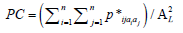
Where n is the total number of natural-agricultural landscape patches in the landscape; ai and aj are the areas of patch i and patch j, respectively; nijis the number of connections between patch i and patch j; AL the area for the background landscape. 0 ≤ IIC ≤ l, the larger the IIC, the better the landscape connectivity between the natural-agricultural landscapes patches. The calculation of PC is shown in equation (2):
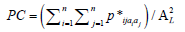
In the formula, p* is the maximum possibility that the ecological flow is directly connected between patch i and patch j. 0<PC<1.
The calculation of the index is done with the help of Conefor Inputs for ArcGIS10.0. During this process, a distance threshold for connectivity of habitat patches in the landscape is specified. Considering the circulation of ecological flow between patches and the accessibility of ecological land, while calculating the IIC value in this study. The distance threshold for patch connectivity was set to 500 m; when calculating PC, the distance threshold was set to 500 m. The probability of connectivity between patches is 0.5.
Spatial-temporal distribution of LULC
The data processing results are shown in Figures 3-5. A substantial change in the land use land cover has been observed in the results. Results shown that before 2000 itself Patancheruvu's urban land expansion has been started, and urban expansion is mainly concentrated on outside of the Nehru Ring Road of Hyderabad City. The characteristics of urban land expansion in Patancheruvu's mainly concentrated in agricultural land. The Northern east side of Patancheruvu's has less urban expansion, mainly in Narasapur side areas, which are related to the Madapur block. It is also observed that the traditional village area of Patancheruvu's have a low degree of expansion and the urban development mainly expand along the NH 65 road around the old town area. In general, the urban expansion of Patancheruvu's started from the traditional core urban area, and the surrounding villages were affected by the spatial radiation of the central city to a certain extent. From the results, it can be seen throughout the study area, the built-up area is happened in nascent patches. It is observed in the southern west part of the image, which represents the Patancheruvu's Industrial area and the core of the town including Kandi, Sadashivapet, Sangamwadi and Kanjerla having high urbanization. The characteristics of urban land expansion in Patancheruvu's from 2000 to 2020 are inseparable from the socioeconomic development of district blocks. Therefore, in the past 20 years, the urban land expansion area is largest around Patancheruvu's.

Figure 3: Land use and land Cover, 2000. 


Figure 4: Land use and land Cover, 2010. 


Figure 5: Land use and land Cover, 2020. 


Analysis of spatiotemporal characteristics of urban land expansion
In the earliest days before 1990, agriculture was the main focus, and it had the largest garden area in Patancheruvu's. But after declaring Patancheruvu's as Industrial area of Hyderabad city, the urban expansion started. In the Greater Hyderabad planning plan, the method of establishing satellite towns was adopted. Future development of the city is proposed to be distributed around the area of industrial zones in order to control and balance the expansion of the urbanization. Thus, promoted the development in outer side of Hyderabad areas. In the past 20 years, urban land has further expanded significantly. The characteristics of urban land expansion in Patancheruvu's are shown in Figures. From Figures, it can be seen that since 2000, its urban expansion mainly concentrated in the outer urban areas far from Hyderabad. At the same time, the urban land area in the inner Hyderabad area remained basically unchanged and remained stable. In general, the expansion of urban land in the past 30 years is mainly concentrated in the outer periphery of the city, that is, the outer part of Hyderabad area, with all around of city.
The characteristics of urban land expansion in Patancheruvu's are shown in Table 2. From Table 2, it can be seen that the urban land expansion in Patancheruvu's in the past 20 years is relatively scattered, with high aggregation, more in the central part of the town, and also in the Western and Eastern areas. The prominent expansion feature is the expansion along the city's main roads. Convenient water and land transportation greatly stimulated the development of early Patancheruvu's industry and commerce. The prosperity of the city has attracted many outsiders to settle here, including a large number of rural population and immigrants. The urban center area has been fully developed earlier, and with the transformation of the economic structure from the 1990s. In the second half of the 20th century, urban economic decline and with the relocation of industrial enterprises, the outskirts have gradually become the growth point of employment, which has stimulated the urban construction in the suburban areas. Therefore, this area has performed more prominently in the urban expansion in the past 20 years.
| City | Land use type | Year 2000 | Year 2010 | Year 2020 |
|---|---|---|---|---|
| Area (ha) | Area (ha) | Area (ha) | ||
| Patancheruvu's | Construction land | 3465.4 | 5105.47 | 6626.84 |
| Agricultural land | 12790.5 | 9968.27 | 7000.19 | |
| Natural land | 1652.43 | 1894.72 | 2986.75 | |
| Waters | 454.19 | 373.34 | 186.67 | |
| Grassland | 304.64 | 1381.37 | 1866.72 |
Table 2: Land use structure of Patancheruvu's for different periods.
Table 2 shows the changes in the area under different land use classes from 2000 to 2020. The change in the area under specific LULC represents the variations in that specific category. It is just a quantitative analysis and does not show the actual picture of where change is observed. From the Table 2, it can be seen that construction land in Patancheruvu's is 3465 ha in 2000. This numbers increased to 5105 ha and 6626 ha with a percentage 2010 and 2020 respectively. At the same period agricultural land was decreased largely from 12790.50 ha to 7000.19 ha in 2000 and 2020 respectively. Agricultural cultivated land decreased and converted in to bare ground. Interestingly, grass land increased nearly 7.15% in between 20 years. This is happened because agricultural lands are converted in to open land, and appeared as grass lands. Major water bodies are appeared in the study area with an estimation of 454.19 ha in 2000 year. This number changed into 186.67 ha in 2020 year. Surrounding water body is dominated by agricultural fields and fallow land which sublime into stretches of barren land, away from the water body. This is also seen in the eastern part in Figures 3-5. Another major built up region is found in the South western part, i.e., at Rudraram, and Nandigram area. The built-up areas which are away from the city, comprise mainly agricultural settlements.
There has been a slight decrease in barren land and hilly areas, which is quite evident from the fact that a lot of excavation of hill slopes has taken place and barren lands have been replaced by settlements the last decade. Dense mountain forests appear to have declined and given way to the sparsely forested regions, which can be attributed to the fact that in most cases, afforestation has taken place in last few years. This tells that excavation of hilly slopes in the southern margins of the study area to give way to barren land and sparsely built up areas.
Spatial distribution characteristics of road network density
In ArcGIS 10.2, the natural fracture method is used to classify the density of Patancheruvu's road network. The results tell that the densest areas of Patancheruvu's roads are distributed within the ring road, and the density level is between the Nehru ring road. The density of the inner road network in the traditional urban areas is relatively high, among which the roads in Medak District and Ranga Reddy District are the densest. Because the old city has a long history and obvious development advantages, while the west and north are mostly ecologically fragile areas, the population is relatively sparse. Generally, the distribution characteristics of Patancheruvu's road network show a high density in the southeast and a low density in the northwest, and the trend of decreasing from the traditional old city to the surrounding areas. Road network density characteristics of urban land use change in Patancheruvu's from 2000 to 2020.
Calculation of land use change degree and rate
The land use change obtained by the statistical spatial overlay analysis was used to establish the land use transformation matrix in the work area (Figure 6). According to the land use change index model formula, the land use change rate and comprehensive land use dynamic degree were obtained.

Figure 6: Land use change rate along Patancheruvu. 

The built-up area was extracted according to the image performance characteristics. According to statistics, the built-up area of Patancheruvu's was 18667 ha in 2000. The perspective of land use index, it increased from 18.56% in 2000 to 35.5% in 2020 and the degree of land use increased significantly. Driven by urbanization, from 2000 to 2020, a total of 9822 ha of urban fringe areas in Patancheruvu's were transformed into urban built-up areas, with an average annual change rate of 491ha, a comprehensive land use dynamic degree of 31.02%, and an urban fringe location of 16.92%. The advantages are obvious, and the land use changes are drastic.
During the study period, the area of the unchanged part of land use was 560 ha, the changed part was 18667 ha, and 31.02% of the changed part was cultivated land with an area of 7000.19 ha. Cultivated land is still the main source of urban land expansion. On the one hand, it is because the existing construction land in the urban fringe area has self-renovated and grown itself under the effect of the fringe effect, and has certain characteristics of urban elements, and the corresponding renovation costs are relatively high. The development time is immature; on the other hand, due to the strong demand for urban development land, it shows the typical characteristics of land use change in the period of rapid urban development.
During the study period, the change of non-cultivated land in the urban fringe area (1957 ha) accounted for 10.48% of the total area of non-cultivated land (14747 ha) at the beginning of the 2000 year. Another aspect shows the importance of strengthening the management of land use planning in urban fringe areas. Land in urban fringe areas is gradually incorporated into urban built-up areas in the process of urbanization, and the use attributes have certain historical dependencies. The rational use of land in urban fringe areas affects the area [22].
Connectivity of the natural-agricultural landscape
IIC and PC values of the natural-agricultural landscape connectivity index in Patancheruvu's for three periods are shown in Figures 7 and 8. It can be seen that in 2000, the IIC value and PC value of were higher, and the spatial connectivity of natural and agricultural land was better. With the passage of time, the IIC and PC values of the town continued to decline. Affected by the expansion of construction land, the area of natural and agricultural land continued to decrease, the distance between patches continued to increase, and the spatial connectivity also gradually decreased. The IIC values dropped from 0.72 and 0.42 to 0.25 in 3 periods respectively, and the spatial connectivity of natural and agricultural land dropped significantly, reflecting the obvious damage to the integrity and stability of the local ecosystem due to urban expansion. In comparison, the decrease in PC value was relatively small. The main reason is that in the measurement process of PC, some small fragmented patches act as intermediate patches and plays the role of stepping stones, increasing the possibility of connectivity of disconnected patches in the IIC measurement. From a spatial point of view, no matter which year it is, IIC and PC show a clear urban-rural gradient. Patancheruvu's is close to the central urban area and is greatly affected by urban expansion, and the spatial connectivity of natural and agricultural landscapes has always been poor.

Figure 7: The values of IIC and ecological landscape at Patancheruvu.

Figure 8: The values of PC and ecological landscape at Patancheruvu.
The natural and agricultural ecosystem in the urban-rural fringe is an important foundation to ensure the ecological security of the city. However, the rapid urban expansion often leads to the rapid reduction of these uses. These expansions extremely effecting natural and agricultural landscapes, resulting in a sharp decline in the stability and service functions of regional ecosystems. This study takes typical town (Patancheruvu's) in the urban-rural fringe of Hyderabad city. It is an example study of spatiotemporal evolution law and driving factors of natural and agricultural landscapes in the urban-rural fringe under the background of rapid urbanization. These studies provide scientific support for planning and formulation of ecological protection policies. The study came to the following conclusions:
1. From 2000 to 2020, the town experienced a violent LULC process. The rapid expansion of construction on land is accompanied by the sharp reduction of agricultural land and water area. The area of woodland and grassland in the urban-rural fringe is also decreasing with the expansion of the city.
2. Urban expansion has transformed a large area of agricultural land and extremely important forest lands and wet lands into urban construction land. Agricultural lands and forest lands are demolishing to build residential areas, and the total area of woodland and grassland also decreased substantially. All-natural secondary forest habitats and original artificial mature forests are being destroying at the same time.
3. Most of the newly added construction lands in the town is distributing around the agricultural land, which shows the expansion characteristics of "spreading in pieces" and "spread in the big cake". Due to the increasing of human population existing construction land has a spatial diffusion effect on adjacent agricultural areas. It is resulting in the continuous expansion of construction lands and continuous reduction of the surrounding natural and agricultural landscapes. This has led to the continuous degradation of the living environment.
4. With the rapid expansion of urban, the connectivity of natural and agricultural landscapes in the town declined sharply, and urban expansion significantly damaged the connectivity of the spatial structure of local ecosystems. Spatially, the connectivity of the natural and agricultural landscapes in the three towns presents an obvious urban-rural gradient. The connection between the environment and the agricultural landscape is better, if towns are built away from the central urban areas.
5. A variety of elements, including social and economic development, land use planning, and governmental policies, have contributed to the creation of the natural and agricultural landscape pattern along the urban-rural border. The most direct factors influencing the evolution of natural and agricultural landscapes in the urban-rural fringe are population growth and economic expansion. However, land use planning and public policies also have an impact which cannot be ignored because they regulate the intensity of land uses and have an impact on the distribution of peoples and industries. Instead of relying on the design and construction of green isolation belts surrounding the town, restriction should be taken in the form of the policy and control the expansion of urban construction lands.
[Crossref] [Google Scholar] [PubMed]
[Crossref] [Google Scholar] [PubMed]
[Crossref] [Google Scholar] [PubMed]
Citation: Gudivada BN, Krishna IVM, Vani KM. Urbanization and environmental quality in Patancheruvu, Sangareddy, Telangana: An assessment. AGBIR.2023;39(4):587-591.
Received: 19-May-2023, Manuscript No. AGBIR-23-99004; , Pre QC No. AGBIR-23-99004 (PQ); Editor assigned: 22-May-2023, Pre QC No. AGBIR-23-99004 (PQ); Reviewed: 12-Jun-2023, QC No. AGBIR-23-99004; Revised: 19-Jun-2023, Manuscript No. AGBIR-23-99004 (R); Published: 03-Jul-2023, DOI: 10.35248/0970-1907.23.39.587-591
Copyright: This open-access article is distributed under the terms of the Creative Commons Attribution Non-Commercial License (CC BY-NC) (http:// creativecommons.org/licenses/by-nc/4.0/), which permits reuse, distribution and reproduction of the article, provided that the original work is properly cited and the reuse is restricted to noncommercial purposes. For commercial reuse, contact reprints@pulsus.com This is an open access article distributed under the terms of the Creative Commons Attribution License, which permits unrestricted use, distribution, and reproduction in any medium, provided the original work is properly cited.